| at: |
Breckenridge |
Data from Positive Flow
 show on map
 animate
Trail users:


Elevation Profile
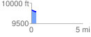
 0.478728 mi
 0.00 ft
 53.23 ft
 -53.23 ft
 2.11 %
GPX Downloads: Track Route
![]()
| at: |
Breckenridge |
show on map
animate
0.478728 mi
0.00 ft
53.23 ft
-53.23 ft
2.11 %