| at: |
Breckenridge |
Data from Positive Flow
 show on map
 animate
Trail users:


Elevation Profile
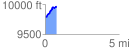
 0.760502 mi
 196.95 ft
 14.82 ft
 182.12 ft
 4.90 %
GPX Downloads: Track Route
![]()
| at: |
Breckenridge |
show on map
animate
0.760502 mi
196.95 ft
14.82 ft
182.12 ft
4.90 %