| at: |
Breckenridge |
Data from Positive Flow
 show on map
 animate
Trail users:


Elevation Profile
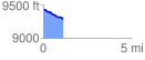
 1.107308 mi
 8.50 ft
 145.75 ft
 -137.25 ft
 2.49 %
GPX Downloads: Track Route
![]()
| at: |
Breckenridge |
show on map
animate
1.107308 mi
8.50 ft
145.75 ft
-137.25 ft
2.49 %