| at: |
Breckenridge |
Data from Positive Flow
 show on map
 animate
Trail users:


Elevation Profile
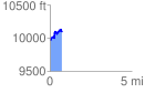
 0.730375 mi
 244.95 ft
 116.45 ft
 128.50 ft
 6.35 %
GPX Downloads: Track Route
![]()
| at: |
Breckenridge |
show on map
animate
0.730375 mi
244.95 ft
116.45 ft
128.50 ft
6.35 %