| at: |
Breckenridge |
Data from Positive Flow
 show on map
 animate
Trail users:


Elevation Profile
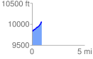
 0.924694 mi
 229.54 ft
 0.00 ft
 229.54 ft
 4.70 %
GPX Downloads: Track Route
![]()
| at: |
Breckenridge |
show on map
animate
0.924694 mi
229.54 ft
0.00 ft
229.54 ft
4.70 %