| at: |
Tom Triplett Community Park |
Data from Positive Flow
 show on map
 animate
Trail users:


Elevation Profile
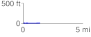
 1.441748 mi
 14.65 ft
 14.01 ft
 0.64 ft
 0.19 %
GPX Downloads: Track Route
![]()
| at: |
Tom Triplett Community Park |
show on map
animate
1.441748 mi
14.65 ft
14.01 ft
0.64 ft
0.19 %