| at: |
Fish Hatchery Area |
Data from Karlos Bernart
 show on map
 animate
Trail users:


Elevation Profile
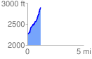
 1.152369 mi
 695.86 ft
 50.46 ft
 645.40 ft
 11.44 %
GPX Downloads: Track Route
![]()
| at: |
Fish Hatchery Area |
show on map
animate
1.152369 mi
695.86 ft
50.46 ft
645.40 ft
11.44 %