|
| at: |
Tray Mountain |
Data from David Muse
 show on map
 animate

Trail users:


Elevation Profile
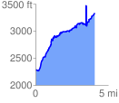
 4.072235 mi
 1839.09 ft
 782.43 ft
 1056.66 ft
 8.55 %
GPX Downloads: Track Route
![]()
|
| at: |
Tray Mountain |
show on map
animate
4.072235 mi
1839.09 ft
782.43 ft
1056.66 ft
8.55 %