| at: |
Tray Mountain Trans North Georgia |
Data from David Muse
 show on map
 animate
Trail users:


Elevation Profile
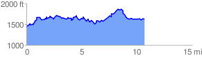
 10.839218 mi
 1605.05 ft
 1405.04 ft
 200.01 ft
 2.80 %
GPX Downloads: Track Route
![]()
| at: |
Tray Mountain Trans North Georgia |
show on map
animate
10.839218 mi
1605.05 ft
1405.04 ft
200.01 ft
2.80 %