|
| at: |
Lake Burton WMA |
Data from USFS GIS
 show on map
 animate
Trail users:


Elevation Profile
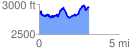
 3.125031 mi
 666.49 ft
 550.64 ft
 115.85 ft
 4.04 %
GPX Downloads: Track Route
![]()
|
| at: |
Lake Burton WMA |
show on map
animate
3.125031 mi
666.49 ft
550.64 ft
115.85 ft
4.04 %