| at: |
Lake Burton WMA |
Data from USFS GIS
 show on map
 animate
Trail users:


Elevation Profile
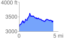
 4.448944 mi
 1042.96 ft
 839.08 ft
 203.88 ft
 4.44 %
GPX Downloads: Track Route
![]()
| at: |
Lake Burton WMA |
show on map
animate
4.448944 mi
1042.96 ft
839.08 ft
203.88 ft
4.44 %