| at: |
Trans North Georgia |
Data from David Muse
 show on map
 animate
Route users:

Elevation Profile
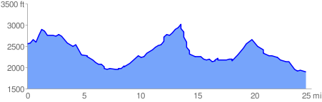
 24.937689 mi
 4406.97 ft
 5112.11 ft
 -705.14 ft
GPX Downloads: Track Route
Cue Sheets:
TNGA 2 (FS32C to Hwy 197)
![]()
| at: |
Trans North Georgia |
show on map
animate
24.937689 mi
4406.97 ft
5112.11 ft
-705.14 ft