| at: |
West Georgia Pinhoti Trans North Georgia Johns Mountain WMA |
Data from David Muse
 show on map
 animate
Trail users:


Elevation Profile
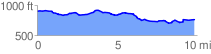
 9.931483 mi
 445.45 ft
 566.02 ft
 -120.57 ft
 1.08 %
GPX Downloads: Track Route
![]()
| at: |
West Georgia Pinhoti Trans North Georgia Johns Mountain WMA |
show on map
animate
9.931483 mi
445.45 ft
566.02 ft
-120.57 ft
1.08 %