| at: |
West Georgia Pinhoti Trans North Georgia Johns Mountain WMA |
Data from David Muse
 show on map
 animate
Trail users:


Elevation Profile
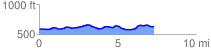
 7.326686 mi
 262.37 ft
 226.29 ft
 36.07 ft
 0.68 %
GPX Downloads: Track Route
![]()
| at: |
West Georgia Pinhoti Trans North Georgia Johns Mountain WMA |
show on map
animate
7.326686 mi
262.37 ft
226.29 ft
36.07 ft
0.68 %