|
| at: |
Windy Gap Mulberry Gap |
Data from USFS GIS
 show on map
 animate
Trail users:


Elevation Profile
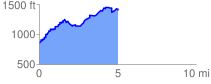
 5.115137 mi
 1441.08 ft
 866.27 ft
 574.80 ft
 5.34 %
GPX Downloads: Track Route
![]()
|
| at: |
Windy Gap Mulberry Gap |
show on map
animate
5.115137 mi
1441.08 ft
866.27 ft
574.80 ft
5.34 %