| at: |
Crockford/Pigeon Mountain WMA |
Data from David Muse
 show on map
 animate
Trail users:


Elevation Profile
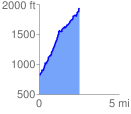
 2.543913 mi
 1256.61 ft
 122.71 ft
 1133.90 ft
 9.36 %
GPX Downloads: Track Route
![]()
| at: |
Crockford/Pigeon Mountain WMA |
show on map
animate
2.543913 mi
1256.61 ft
122.71 ft
1133.90 ft
9.36 %