| at: |
Bent Creek |
Data from David Muse
 show on map
 animate
Trail users:


Elevation Profile
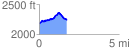
 1.723769 mi
 237.59 ft
 169.93 ft
 67.66 ft
 2.61 %
GPX Downloads: Track Route
![]()
| at: |
Bent Creek |
show on map
animate
1.723769 mi
237.59 ft
169.93 ft
67.66 ft
2.61 %