| at: |
Pinelog WMA |
Data from David Muse
 show on map
 animate
Trail users:


Elevation Profile
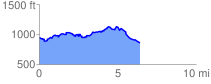
 6.564006 mi
 608.32 ft
 719.01 ft
 -110.69 ft
 2.07 %
GPX Downloads: Track Route
![]()
| at: |
Pinelog WMA |
show on map
animate
6.564006 mi
608.32 ft
719.01 ft
-110.69 ft
2.07 %