| at: |
Cohutta Pinhoti Trans North Georgia Mulberry Gap |
Data from David Muse
 show on map
 animate
Trail users:


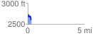
Elevation Profile
 0.302227 mi
 70.09 ft
 134.29 ft
 -64.19 ft
 8.42 %
GPX Downloads: Track Route
![]()
| at: |
Cohutta Pinhoti Trans North Georgia Mulberry Gap |
show on map
animate
0.302227 mi
70.09 ft
134.29 ft
-64.19 ft
8.42 %