| at: |
James H. Floyd State Park |
Data from David Muse
 show on map
 animate
Trail users:

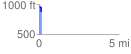
Elevation Profile
 0.155928 mi
 2.62 ft
 102.36 ft
 -99.74 ft
 12.43 %
GPX Downloads: Track Route
![]()
| at: |
James H. Floyd State Park |
show on map
animate
0.155928 mi
2.62 ft
102.36 ft
-99.74 ft
12.43 %