| at: |
James H. Floyd State Park |
Data from David Muse
 show on map
 animate
Trail users:

Elevation Profile
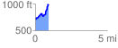
 0.917861 mi
 342.85 ft
 113.52 ft
 229.33 ft
 7.07 %
GPX Downloads: Track Route
![]()
| at: |
James H. Floyd State Park |
show on map
animate
0.917861 mi
342.85 ft
113.52 ft
229.33 ft
7.07 %