| at: |
James H. Floyd State Park |
Data from David Muse
 show on map
 animate
Trail users:

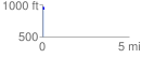
Elevation Profile
 0.081688 mi
 0.00 ft
 46.92 ft
 -46.92 ft
 10.88 %
GPX Downloads: Track Route
![]()
| at: |
James H. Floyd State Park |
show on map
animate
0.081688 mi
0.00 ft
46.92 ft
-46.92 ft
10.88 %