| at: |
James H. Floyd State Park |
Data from David Muse
 show on map
 animate
Trail users:

Elevation Profile
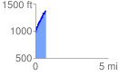
 0.719866 mi
 458.01 ft
 55.12 ft
 402.89 ft
 12.05 %
GPX Downloads: Track Route
![]()
| at: |
James H. Floyd State Park |
show on map
animate
0.719866 mi
458.01 ft
55.12 ft
402.89 ft
12.05 %