| at: |
Santos |
Data from Karlos Bernart
 show on map
 animate
Trail users:


Elevation Profile
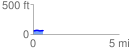
 0.560921 mi
 24.02 ft
 13.68 ft
 10.33 ft
 0.81 %
GPX Downloads: Track Route
![]()
| at: |
Santos |
show on map
animate
0.560921 mi
24.02 ft
13.68 ft
10.33 ft
0.81 %