| at: |
West Georgia Pinhoti |
Data from David Muse
 show on map
 animate
Trail users:

Elevation Profile
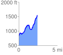
 2.435459 mi
 1052.20 ft
 313.22 ft
 738.98 ft
 8.18 %
GPX Downloads: Track Route
![]()
| at: |
West Georgia Pinhoti |
show on map
animate
2.435459 mi
1052.20 ft
313.22 ft
738.98 ft
8.18 %