| at: |
West Georgia Pinhoti Johns Mountain WMA Dry Creek |
Data from David Muse
 show on map
 animate
Trail users:


Elevation Profile
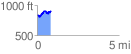
 0.849941 mi
 171.95 ft
 121.36 ft
 50.60 ft
 3.83 %
GPX Downloads: Track Route
![]()
| at: |
West Georgia Pinhoti Johns Mountain WMA Dry Creek |
show on map
animate
0.849941 mi
171.95 ft
121.36 ft
50.60 ft
3.83 %