|
| at: |
West Georgia Pinhoti Johns Mountain WMA |
Data from David Muse
 show on map
 animate
Trail users:


Elevation Profile
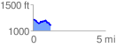
 1.251570 mi
 115.67 ft
 216.20 ft
 -100.53 ft
 3.27 %
GPX Downloads: Track Route
![]()
|
| at: |
West Georgia Pinhoti Johns Mountain WMA |
show on map
animate
1.251570 mi
115.67 ft
216.20 ft
-100.53 ft
3.27 %