|
| at: |
South Fork |
Data from David Muse
 show on map
 animate
Trail users:


Elevation Profile
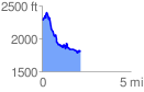
 2.214359 mi
 410.16 ft
 891.34 ft
 -481.18 ft
 7.62 %
GPX Downloads: Track Route
![]()
|
| at: |
South Fork |
show on map
animate
2.214359 mi
410.16 ft
891.34 ft
-481.18 ft
7.62 %