| at: |
Camp Thunder |
Data from Dean Thornton
 show on map
 animate
Trail users:


Elevation Profile
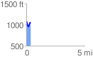
 0.352456 mi
 100.90 ft
 149.88 ft
 -48.99 ft
 8.05 %
GPX Downloads: Track Route
![]()
| at: |
Camp Thunder |
show on map
animate
0.352456 mi
100.90 ft
149.88 ft
-48.99 ft
8.05 %