| at: |
Camp Thunder |
Data from Dean Thornton
 show on map
 animate
Trail users:


Elevation Profile
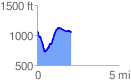
 2.084641 mi
 430.26 ft
 456.25 ft
 -25.98 ft
 4.15 %
GPX Downloads: Track Route
![]()
| at: |
Camp Thunder |
show on map
animate
2.084641 mi
430.26 ft
456.25 ft
-25.98 ft
4.15 %