| at: |
Ashland Watershed |
Data from Jason Sager
 show on map
 animate
Trail users:


Elevation Profile
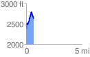
 0.687028 mi
 465.08 ft
 210.70 ft
 254.38 ft
 12.82 %
GPX Downloads: Track Route
![]()
| at: |
Ashland Watershed |
show on map
animate
0.687028 mi
465.08 ft
210.70 ft
254.38 ft
12.82 %