| at: |
Ashland Watershed |
Data from Jason Sager
 show on map
 animate
Trail users:


Elevation Profile
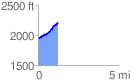
 1.209711 mi
 309.07 ft
 31.84 ft
 277.22 ft
 4.84 %
GPX Downloads: Track Route
![]()
| at: |
Ashland Watershed |
show on map
animate
1.209711 mi
309.07 ft
31.84 ft
277.22 ft
4.84 %