| at: |
South Fork |
Data from USFS GIS
 show on map
 animate
Trail users:

Elevation Profile
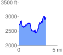
 3.580663 mi
 1499.47 ft
 1296.20 ft
 203.27 ft
 7.93 %
GPX Downloads: Track Route
Trailheads:
 Watson Gap
![]()
| at: |
South Fork |
show on map
animate
3.580663 mi
1499.47 ft
1296.20 ft
203.27 ft
7.93 %
Watson Gap