| at: |
South Fork |
Data from USFS GIS
 show on map
 animate
Trail users:

Elevation Profile
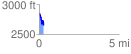
 0.295942 mi
 57.45 ft
 268.22 ft
 -210.76 ft
 17.16 %
GPX Downloads: Track Route
![]()
| at: |
South Fork |
show on map
animate
0.295942 mi
57.45 ft
268.22 ft
-210.76 ft
17.16 %