| at: |
South Fork |
Data from USFS GIS
 show on map
 animate
Trail users:

Elevation Profile
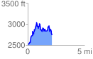
 2.185645 mi
 1079.42 ft
 871.34 ft
 208.08 ft
 9.35 %
GPX Downloads: Track Route
Trailheads:
 Watson Gap
![]()
| at: |
South Fork |
show on map
animate
2.185645 mi
1079.42 ft
871.34 ft
208.08 ft
9.35 %
Watson Gap