| at: |
Santos |
Data from USFS GIS
 show on map
 animate
Trail users:


Elevation Profile
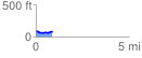
 0.877237 mi
 84.50 ft
 85.80 ft
 -1.29 ft
 1.85 %
GPX Downloads: Track Route
![]()
| at: |
Santos |
show on map
animate
0.877237 mi
84.50 ft
85.80 ft
-1.29 ft
1.85 %