| at: |
Santos |
Data from USFS GIS
 show on map
 animate
Trail users:


Elevation Profile
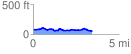
 3.480083 mi
 311.61 ft
 325.35 ft
 -13.74 ft
 1.77 %
GPX Downloads: Track Route
![]()
| at: |
Santos |
show on map
animate
3.480083 mi
311.61 ft
325.35 ft
-13.74 ft
1.77 %