| at: |
Santos |
Data from USFS GIS
 show on map
 animate
Trail users:


Elevation Profile
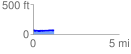
 1.239938 mi
 57.99 ft
 64.28 ft
 -6.29 ft
 0.98 %
GPX Downloads: Track Route
![]()
| at: |
Santos |
show on map
animate
1.239938 mi
57.99 ft
64.28 ft
-6.29 ft
0.98 %