| at: |
Santos |
Data from USFS GIS
 show on map
 animate
Trail users:


Elevation Profile
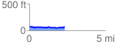
 2.338110 mi
 144.65 ft
 141.40 ft
 3.25 ft
 1.17 %
GPX Downloads: Track Route
![]()
| at: |
Santos |
show on map
animate
2.338110 mi
144.65 ft
141.40 ft
3.25 ft
1.17 %