| at: |
Bear Creek/Mountaintown Cohutta Pinhoti Mulberry Gap |
Data from David Muse
 show on map
 animate
Route users:

Elevation Profile
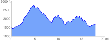
 18.361685 mi
 4704.02 ft
 4704.02 ft
 0.00 ft
GPX Downloads: Track Route
![]()
| at: |
Bear Creek/Mountaintown Cohutta Pinhoti Mulberry Gap |
show on map
animate
18.361685 mi
4704.02 ft
4704.02 ft
0.00 ft