| in: |
Chattahoochee National Forest - Conasauga Ranger District |
near: |
Ellijay,
Georgia |
 show on map
 printable map
Last Trail Update: 2017-12-26
printable map
Last Trail Update: 2017-12-26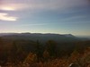


Hours:
24/7 except during organized hunts, use caution and courtesy during hunting season
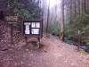
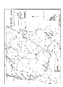
Maps:
Routes:
2010 Drama Queen (Long Option) - 51.46 mi
2010 Drama Queen (Short Option) - 35.76 mi
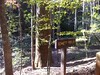
Bear Creek - 12.61 mi
Bear Creek - Mountaintown Loop - 22.35 mi
Ellijay Big Loop - 34.61 mi
Mulberry Gap - Bear Creek, P1 and P2 - 18.36 mi
Mulberry Gap - Bear Creek, P1, P2 and P3 - 25.80 mi
Original Firewater 50 - 42.09 mi
Trailheads:
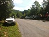
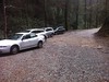
 Bear Creek Lower Parking LotBear Creek Upper Parking LotGates Chapel Road Parking AreaUpper Mountaintown Creek
Total Mileage: (note)
 Hiking Trail - 1.37 mi Bike Trail - 9.00 mi Dirt/Gravel Road - 43.74 mi Unmaintained Road - 1.21 mi
Trails:
Barnes Creek - 0.04 mi Bear Creek/Mountaintown Connector - 1.33 mi Bear Creek Cutoff - 0.16 mi Bear Creek Loop Trail - 0.58 mi Bear Creek Spur - 0.30 mi | AKA: |
Bear Creek Switchbacks |
Bear Creek Trail - 2.40 mi Mountaintown Creek Trail - 5.57 mi Roads:
Bear Creek Campground Lot - 0.06 mi FS241 - 2.09 mi | AKA: |
Bear Creek Camp Road |
FS286 - 0.52 mi | AKA: |
Land Road |
FS304 - 5.35 mi | AKA: |
Bear Creek Loop Trail Little Bear Creek Road |
FS64 - 13.95 mi | AKA: |
Three Forks Road |
FS68 - 11.71 mi | AKA: |
Conasauga Lake Road Potato Patch Road |
FS90 - 1.66 mi | AKA: |
Barnes Creek Road |
Harper Creek Road - 0.71 mi Riggs Road - 1.94 mi (Private) | AKA: |
Hills Lake Road |
Whitecliff Drive - 1.62 mi Whitecliff Drive (Private) - 0.56 mi (Private) Wolfpen Gap Road - 1.34 mi Zion Hill Road (Unpaved) - 2.22 mi FS425 - 1.21 mi Flat Branch Road - 5.15 mi Gates Chapel Road - 5.35 mi Weeks Road - 1.47 mi Zion Hill Road - 3.02 mi Points of Interest:
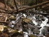
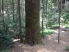
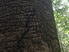
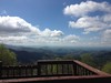
 Bear Creek OverlookGennett PoplarBarnes Creek FallsMountaintown Overlook