| at: |
Cohutta Pinhoti Mulberry Gap Rock Creek/Tatum Lead ORV Trails |
Data from David Muse
 show on map
 animate
Route users:

Elevation Profile
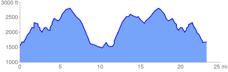
 23.545582 mi
 6696.01 ft
 6696.01 ft
 0.00 ft
GPX Downloads: Track Route
![]()
| at: |
Cohutta Pinhoti Mulberry Gap Rock Creek/Tatum Lead ORV Trails |
show on map
animate
23.545582 mi
6696.01 ft
6696.01 ft
0.00 ft