| at: |
Rock Creek/Tatum Lead ORV Trails Cohutta Pinhoti Trans North Georgia Mulberry Gap |
Data from David Muse
 show on map
 animate
Trail users:


Elevation Profile
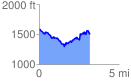
 3.210633 mi
 622.25 ft
 729.81 ft
 -107.56 ft
 4.31 %
GPX Downloads: Track Route