| at: |
Bear Creek/Mountaintown Mulberry Gap |
Data from David Muse
 show on map
 animate
Trail users:


Elevation Profile
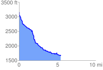
 5.568085 mi
 316.58 ft
 1809.99 ft
 -1493.41 ft
 6.16 %
GPX Downloads: Track Route
Trailheads:
 Upper Mountaintown Creek