| in: |
Atlanta Metro Area |
near: |
Dawsonville,
Georgia |
 show on map
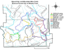
 printable map
Last Trail Update: 2020-11-28
printable map
Last Trail Update: 2020-11-28


Hours:
24/7 use caution and courtesy during hunting season
Maps:
Trailheads:
 Dawson Forest
Total Mileage: (note)
 Bike/Horse Trail - 15.50 mi Dirt/Gravel Road - 25.43 mi Unmaintained Road - 3.40 mi
Trails:
Blue Trail (Section 10) - 2.56 mi Blue Trail (Section 11, Etowah Ford) - 0.12 mi Blue Trail (Section 16) and Orange Trail (Section 2) - 0.64 mi Blue Trail (Section 1) and Red Trail (Section 1) - 0.20 mi Blue Trail (Section 2) and Red Trail (Section 2) - 0.19 mi Blue Trail (Section 5) and Red Trail (Section 5) - 1.54 mi Blue Trail (Section 8) - 1.66 mi Green Trail (Section 2) - 0.76 mi Orange Trail (Section 5) - 2.57 mi Orange Trail (Section 7) - 1.11 mi Pink Trail (Section 2) - 0.74 mi Red Trail (Section 7) - 2.13 mi Winston Road (Section 1) and Blue Trail (Section 13) - 1.12 mi Winston Road (Section 2) and Blue Trail (Section 14) and Orange Trail (Section 4) - 0.19 mi Roads:
Amicalola Field Road - 1.10 mi Azalea Ridge Road - 5.14 mi Beaverdam Road (Section 1) and Blue Trail (Section 4) and Red Trail (Section 4) - 0.37 mi Beaverdam Road (Section 2) and Red Trail (Section 8) - 0.44 mi Clarke Road (Orange Trail) - 1.72 mi Duckpond Road (Section 1) - 0.11 mi Duckpond Road (Section 2) and Blue Trail (Section 17) and Orange Trail (Section 1) - 0.38 mi Duckpond Road (Section 3, Unexplored) - 0.10 mi North Gate Road (Section 1) - 4.19 mi North Gate Road (Section 2) and Blue Trail (Section 9) - 0.21 mi North Gate Road (Section 3) and Yellow Trail - 0.85 mi Powerline Road (Section 1) and Blue Trail (Section 1) - 0.19 mi Powerline Road (Section 2) and Red Trail (Section 6) - 0.85 mi Powerline Road (Section 3) - 0.51 mi Railroad Road (Section 1) - 0.17 mi Railroad Road (Section 1, Unexplored) - 0.14 mi Railroad Road (Section 2) and Blue Trail (Section 12) - 0.49 mi Railroad Road (Section 3) and Pink Trail (Section 1) - 0.67 mi Railroad Road (Section 4) - 0.18 mi Reservoir Road (Section 1) - 0.49 mi Reservoir Road (Section 2) and Blue Trail (Section 15) and Orange Trail (Section 3) - 0.22 mi Rock Terrace Road - 2.07 mi Shoal Creek Road (Section 1) - 0.18 mi Shoal Creek Road (Section 2) and Blue Trail (Section 3) and Red Trail (Section 3) - 0.28 mi Shoal Creek Road (Section 3) - 1.56 mi Shoal Creek Road (Section 4) and Blue Trail (Section 7) - 1.48 mi Shoal Creek Road (Section 5) - 1.34 mi Green Road (Section 1) - 0.21 mi Green Road (Section 2) and Orange Trail (Section 8) - 0.54 mi Green Road (Section 3) - 0.19 mi Mill Road (Section 1) and Orange Trail (Section 6) - 0.96 mi Mill Road (Section 2) - 0.64 mi Ram Road and Green Trail (Section 1) - 0.88 mi Dawson Forest Road (Section 1) - 1.66 mi Dawson Forest Road (Section 2, Unexplored) - 2.07 mi Dawson Forest Road (Section 3) - 0.19 mi Dawson Forest Road (Section 4, Unexplored) - 0.83 mi